Table of Contents
Walking in the Calvia Hills: The Trails Most Southwest Mallorca Residents Never Find
Most people who live in Santa Ponsa, Peguera or El Toro know the coastline well. They know where to swim, where to park, which beach gets busy by 10am. What fewer people know is that the hills behind them — the Calvià municipal territory stretching inland from the coast — hold a network of marked walking trails that make for some of the most satisfying short walks on the island.
None of these require a car to reach from the southwest. None of them involve crowds. And most take under two hours return. This is walking as residents actually do it, not as the tourist guides describe it.
Thinking about buying or selling in Mallorca?
The Landscape Behind the Coast
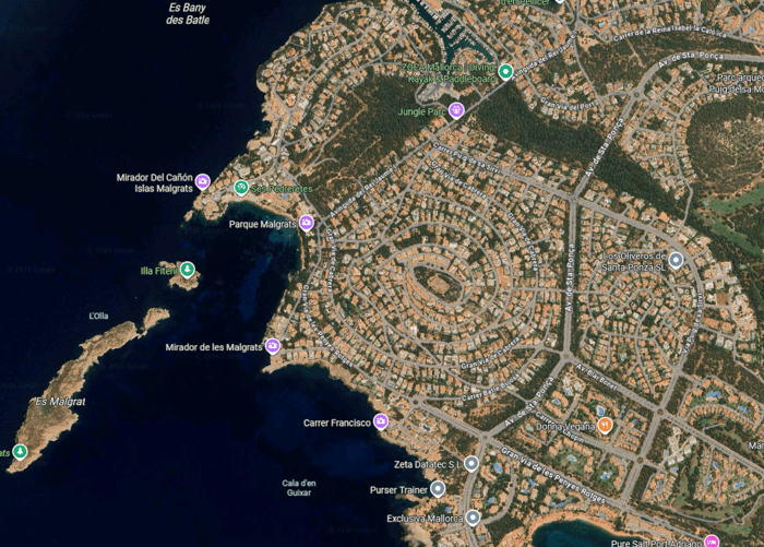
The term "southwest Mallorca" tends to conjure beaches, marinas and golf courses. The interior tells a different story. Behind the coastal strip, the land rises into a series of limestone ridges covered in Aleppo pine, wild rosemary, lentisk and dwarf fan palm. In spring, the hillsides carry asphodels and wild orchids. In summer, the shade under the pines is real and the views over the bay are exceptional.
The Calvià municipality is the largest by area in the Balearics. Much of it is protected land — the Cala Figuera nature area, the pine forests around Santa Ponsa and the agricultural land of the interior are all under various levels of protection that have kept development at bay. The result is that you can walk out of a residential street in Santa Ponsa and be in genuine scrubland within ten minutes.
The Santa Ponsa Coastal Path
The most accessible walk from Santa Ponsa itself follows the coastline east from Platja de Santa Ponsa past the smaller coves — Cala Peguera, Cala Vinyes — before turning inland. The path is well-maintained by the Calvià council and marked at intervals. The section from the main beach to the headland above Cala Vinyes takes around 45 minutes at a comfortable pace and offers sea views for most of the route.
Early morning is the best time — before 9am in summer, you have the path almost entirely to yourself. The light on the water at that hour, looking back west toward the bay, is worth the early start.
Puig de Sa Morisca
Just inland from Santa Ponsa stands Puig de Sa Morisca, a low limestone hill with an archaeological site at its summit — the remains of a Bronze Age and Talayotic settlement that was excavated in the late twentieth century. The hill is now a protected heritage site and the walk to the top is short but satisfying: around 30 minutes from the road, with panoramic views over the bay of Santa Ponsa, Nova Santa Ponsa and, on a clear day, toward Palma.
The Talayotic ruins themselves are modest but genuine — stone enclosures and the remnants of dry-stone defensive walls that date to between 1000 and 123 BC. There is no entry fee and no crowds. It is one of those places that locals drive past for years without stopping.
The Peguera Hinterland
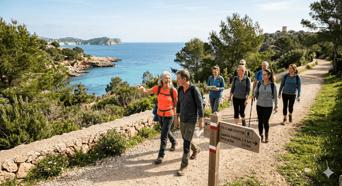
Peguera and the adjacent Costa de la Calma sit at the foot of hills that rise sharply to the north. Several signed trails head upward from the residential streets above the town, entering the pine forest quickly and staying in it for most of the route. The longest of these — a circular route that takes around 90 minutes — gives views back down over the Peguera valley, the offshore islands of El Toro and La Mola, and on clear days the distant Serra de Tramuntana.
These trails are used regularly by local residents for morning exercise. You are unlikely to meet more than a handful of people. The surface is mostly compacted earth and loose stone — trail shoes or sturdy trainers are adequate; proper boots are not needed.
Cala Figuera Nature Area
South of Santa Ponsa, the Cala Figuera headland is a protected natural area that forms the southern boundary of the bay. The walking here is different in character — flatter, more coastal, with rocky shoreline and scrub rather than forest. The area is accessible on foot from the southern end of Santa Ponsa and takes around 40 minutes to reach the tip of the headland from the edge of the town.
The cove at Cala Figuera itself is one of the quieter spots on the southwest coast — small, pebbly and largely unknown to anyone who hasn't walked there. In summer it sees some use from boats anchoring off, but foot traffic is light.
Practical Notes
Summer walking in Mallorca requires basic preparation. Start before 9am or after 6pm — the midday heat between June and September is not suitable for sustained walking on exposed terrain. Carry water: a litre per person per hour is a reasonable minimum in warm conditions. Wear sun protection even on overcast days.
The trails described above do not require navigation equipment beyond a simple map or a trail app. The Wikiloc platform has user-contributed tracks for most of these routes, which can be downloaded for offline use before you set out. The Calvià council publishes walking route information on its municipal website.
Dogs are welcome on all the routes described here. Keep them on leads near roads and respect other walkers — the trails are shared.
Why This Matters for Residents
One of the things that surprises people who move to the southwest from cities is how much accessible outdoor space there is within walking distance of home. The beach gets most of the attention, but the hills and headlands add a different dimension to daily life that doesn't require driving anywhere or paying for access.
If you're thinking about what everyday life in Santa Ponsa or Peguera actually looks like — beyond the sales brochure version — this is part of the answer. A 6am walk in the pine hills above town before the heat builds is as good a way to start a day as exists.
Imperial Properties has been helping people find homes in the southwest since 1985. If you'd like to know more about what living here involves — practically, not theoretically — the team is happy to talk. Browse current listings at imperial-properties.com or get in touch directly.