Table of Contents
Puig Major and the Radar Dome: Mallorca's Highest, Strangest Summit
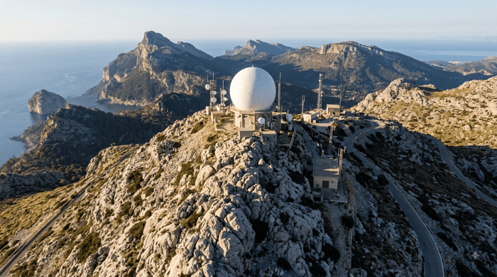
Drive the road between Sóller and Lluc and you'll see it long before you reach it: a pale sphere sitting on top of the island's highest mountain, visible from much of the Tramuntana and, on a clear day, from parts of the southwest coast too. Puig Major rises to 1,445 metres above sea level in the municipality of Escorca, making it the tallest point in Mallorca and in the Balearic Islands as a whole. Almost nobody has stood on its actual summit, and that's entirely intentional.
A Cold War Installation That Never Left
The sphere is a military radar station, built by the United States Air Force between 1957 and 1959 under the Friendship Agreements signed between Spain and the US in 1953, arrangements that traded American military infrastructure on Spanish soil for economic and material aid. The station was operated by the USAF's 880th Aircraft Control and Warning Squadron until 1993 and has since passed to Spain's Ejército del Aire, the Air Force, which still runs it today as part of NATO's air surveillance network for the Western Mediterranean.
The original installation used two orange spheres, known locally as ses bolles, which were modernised in 2005 and consolidated into the single dome visible today. Building the station meant levelling part of the natural summit, which cost the peak roughly nine metres of its original height, and the access road built for construction crews in 1958 still climbs the mountain in a route so direct it ignores the natural contours of the terrain entirely.
Thinking about buying or selling in Mallorca?
Why the Summit Stays Closed
The actual peak remains an active military zone, and public access to it has been formally ruled out by Spain's central government, most recently in response to a request from a regional senator asking whether the defence rationale still applied now that Cold War tensions have long since passed. The answer, at least so far, has stayed no. Because of that, hikers and cyclists on the island have quietly shifted their attention to the neighbouring Puig de Massanella, at 1,364 metres the highest point in Mallorca that's actually open to the public, and now generally treated as the island's practical summit even though it isn't the tallest.
The lower slopes and access roads around Puig Major are also affected by separate environmental protections, since the area falls within a natural resources management plan designed to protect the Tramuntana's flora and fauna, and much of the terrain on the approach crosses private land. Between the military restrictions and the environmental ones, reaching even the base of the closed zone takes some planning.
What You Can Actually Do
None of this stops the mountain from being one of the most photographed features of the Tramuntana skyline. The road below the restricted military gate is a well-known cycling climb, roughly 6.7 kilometres long with an average gradient over 8%, and it draws serious cyclists from across the island who ride it for the challenge without expecting to reach the top. The Sóller tunnel runs beneath the massif, and the reservoirs of Cúber and Gorg Blau, both accessible and popular for walking, sit right at the mountain's base, offering some of the best straightforward views of the peak and its dome without needing any permission at all.
A Landmark Best Appreciated From Below
Puig Major is a useful reminder that not every part of Mallorca has been opened up for visitors, and that some of the island's most visible landmarks carry a genuinely strange history once you look past the view. For residents in the southwest, it's the pale dot on the northern horizon on a clear day, a small, permanent piece of Cold War infrastructure quietly doing its job on top of the island's highest point, decades after the tensions that put it there.